Winter Storm Watch: Up To Eight Inches Of Snow Possible This Weekend
Get your shovels and snow blowers out, looks like you’re going to need it this weekend. According to 10TV, a significant snowfall is headed to Ohio. Several inches of accumulation is possible over an extended period of time beginning late Saturday night and continuing into Monday morning.
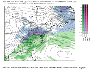
The latest GFS computer model maintains an ideal track for heavy snow in Central Ohio. The model shows around 8″ of snow along the I-70 corridor with isolated higher amounts north of I-70. This is a slight shift north compared to yesterday when the band of heaviest snow was just south of I-70.


